
2017 calendarThe Seven Portals of Kyoto
SCROLL
The basic theme for our calendar for the year 2017 is what is known as the seven portals of Kyoto, the term “portal” being “kuchi” in Japanese. They represent the entry-exit points for travel into and out of the city along the main roads which connected the outer provinces to Kyoto. Some are perhaps unfamiliar to Kyotoites themselves today, while someare known mainly because they are familiar place names; the name of a bus stop or train station and the surrounding neighborhood. The reason that the grouping called “the seven portals of Kyoto” exists, despite the fact that there have been at least nine such historical “kuchi” or inlets-outlets to the city, derives from the circumstances of these particular seven in the history of this city. We can pinpoint a year in that long history: the year 1591. After centuries of political strife in Kyoto and throughout the country, and the ups and downs of imperial authoritychallenged and usurped by various men of the military class, at last the political center of the nation had returned to Kyoto, the seat of the emperor and the country’s cultural hub since the time of Kyoto’s founding as the Heian Capital in the year 794. By the year 1591, however, the emperor himself had become not much more than a figurehead, veritably confined to his palatial enclave in the city, as arranged by his military-class benefactors. We are looking at the dramatic era of the brilliant general, Toyotomi Hideyoshi (1536—98), who became the nation’s leader after he avenged the death of his warlord master, Oda Nobunaga (1534—82), remembered as the first military leader to at last unify the nation under the name of the imperial court after centuries of internal conflict. Save for Emperor Kammu himself, who established the Heian Capital, “Capital of Peace,” in this location in 794, Toyotomi Hideyoshi may well be considered the man who exerted the greatest influence on this city in terms of its city plan.
Hideyoshi, who was of humble origins and seems to have turned into quite a megalomaniac toward the end of his amazing career which has placed him firmly in Japan’s history books, reconstructed the scarred city of Kyoto. The reconstruction was part and parcel of his reunification of the nation with Kyoto as its center. Willing to spend any amount of financial and human resources in the task, he set upon remapping the streets according to its original plan when Kyoto became the Heian Capital centuries previously, arranging the city into neatly blocked areas, and achieving much more in terms of rebuilding Kyoto into a magnificent capital. The year 1591, when he was in the midst of this astonishing project, was the year that he ordered the construction of a massive wall, together with an exterior moat (at some places the moat made use of existing rivers, ponds, and swamps), around the perimeter of the main area of the capital, the area known as Rakuchu. The suburbs outside this area was called Rakugai. These notions of “the area of the capital proper” and “the suburban areas” was nothing new, but Hideyoshi’s wall was the first time for a boundary to be clearly delineated.
The massive wall ― more like a great mound encircling the city ― was meant as a fortification both against enemy intrusion as well as flooding, a natural disaster that the capital had often suffered. It had seven portals connecting to the outside world, these portals representing the gates of ingress and egress to the Rakuchu area. The portals were where the major roads communicating the suburbs and outlying provinces to the capital began and ended. The approximately 23 kilometers, or nearly 15 miles, of wall known as the odoi (dirt enclosure) was built of dirt and stone. Apparently it was between 4 to 5 meters in height, and 4 to 18 meters in thickness at its foot, and was planted with bamboo and other trees and shrubs, to hold the dirt. There are only a few portions which remain extant, as reminders of this significant construction project undertaken by Hideyoshi, since most of it was later torn down to make way for the expanding city, or eroded during the course of time. The wall and its portals have become much a part the forgotten past, though the extant portions of the wall have been designated as national historical relics and are now protected.
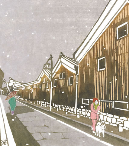
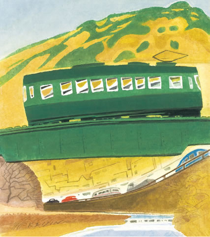
The calendar pages take up certain ‘attractions’ seen today around the old neighborhoods related to “the seven portals of Kyoto.” For the January-February page, the theme is the location called Ohara-guchi, in the north-eastern part of the city, and we see the charming Keifuku Railway tram which for many decades has commuted from the market area which developed around Ohara-guchi, the area called Demachi, to the mountainous district beyond. Ohara-guchi was the portal for travel on the Wakasakaido highway, which led through the mountain pass below Mount Hiei to the Ohara countryside ― the pass depicted in the calendar picture ― and all the way to Wakasa Bay facing the Japan Sea. The Wakasakaido highway was popularly referred to as the sabakaido, or “mackerel highway,” for it afforded the people of the inner city, far removed from any sea, with a good supply of this tasty sea fish.
The March-April page brings us to Tanba-guchi in the south-western area of the city. There is a Japan Railways station today which carries this name. Tanba-guchi was the portal for the San’in highway which led over the Katsura River and connected Kyoto to the province of Tanba in the west. Along the highway, there is the town of Kameoka, which has today developed into a modern municipality. At the Grand Izumo Shrine in Kameoka, annually on April 18 a Flower Festival to appease the fallen cherry-blossom petals is held, which originated as a ritual to pray for rain.
For the May-June page, the theme is Kurama-guchi, leading onto the treacherous old Kuramakaido highway that goes to Kurama-dera temple in the rugged northeastern mountains. The temple Kurama-dera, which origins date to the year 770 and was recognized by Emperor Kammu himself, attracts thousands of sightseers the night of October 22 annually, for the exciting Fire Festival held by Yuki Shrine within its precincts. For the calendar, however, we have the Takekirie-shiki bamboo-cutting ceremony held on June 20, which is based on the legend that the priest Buen, sometime during the years 889—98, conquered an evil serpent by means of his religious power. Dressed as warrior priests, the performers, divided into the Omi and Tanba camps, compete in chopping huge lengths of green bamboo, representing the serpent.
July-August brings us to Kojin-guchi, familiar as a major intersection in the northeast section of the city. Eastward from here, a road leads through a pass in the eastern mountain range, for access to and from the area of Otsu and Lake Biwa in neighboring Shiga Prefecture. It seems that this geographical point in Kyoto was known by other names in older times, but came to be known as Kojin-guchi when Gojoin temple, more commonly known as Kiyokojin temple, was moved to its present location just west of this location, to a key spot in the Teramachi, or “temple neighborhood,” district which Hideyoshi organized as a part of his great scheme. The “Kojin” of Kojin-guchi refers to the deity that protects the hearth, the deity that protects against fire, and the temple Gojoin is dedicated to this deity. On the calendar, we have an artistic illustration of the front entrance of this rather small temple. Located close to the southeastern corner of the Imperial Palace grounds, Gojoin served the role of protecting the Imperial Palace against fire, and for this, out of the hundreds of smaller temples to be found in Kyoto, it was patronized by the imperial family.
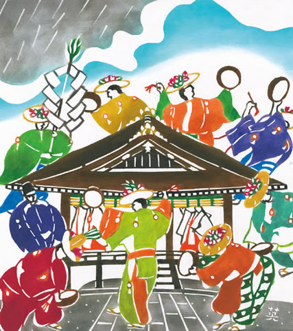
The September-October page shows a scene during the Awata Festival of Awata Shrine, located near the major portal called Awata-guchi, which led onto the famous Tokaido Highway connecting Kyoto to Edo, the government center that was renamed Tokyo around the beginning of Japan’s ‘modern’ period in history. Awata Shrine has been known as the guardian shrine for travelers, as they would pray here for safety along the way. The grand festival takes place over several day during the early part of October, and is said to have a history going back to the year 1001 A.D.
The page for November-December features a scene of the Toji temple compound on December 21, the final Kobo memorial day of the year. This page represents the portal called Toji-guchi, also known as Toba-guchi, in terms of our calendar theme of the seven portals of Kyoto. The portal, not far from today’s JR Kyoto Station, was the one furthest south-west, and led onto the roads connecting to the western and northwestern provinces. Kyoto’s famous Toji temple, with its familiar five-story pagoda, is in this corner of the city, and attracts many people on the festival days held on the 21st of every month in memory of Kobo Daishi, the temple’s founding priest.
The original artwork in this calendar was created by textile-dying artists of Kyoto, especially for this calendar.
Gretchen Mittwer
Cover:Around the Fushimi-guchi Portal to Kyoto
Among the seven portals in the wall built in 1591 to protect the capital proper, the one in the far southeastern corner led onto a highway which Hideyoshi himself is said to have ordered the construction of, to connect the capital to the district of Fushimi, located not far from Kyoto city in that direction. In his late career, Hideyoshi constructed a castle for himself in Fushimi, where he spent his last years, and where a flourishing castle town developed. This area has been known for its saké breweries, and the artwork on the calendar cover portrays a scene of the traditional old saké warehouses which exist even today, and which are representative features of the town ― today an independent municipality of Kyoto prefecture ― of Fushimi. Legend has it that rice cultivation in Japan began in this district, as told in the lore of the famous local shrine, Fushimi Inari. Fushimi has also been blessed by an abundant supply of wonderful-quality water. Rice and good water are the ingredients for good saké, and so Fushimi has thrived as a saké-producing center.
January - February:Around the Ohara-guchi Portal to Kyoto
The art work on this page was created for this calendar by Kyoto textile artist Keijin Ihaya. The scene is of the Eiden tram crossing the Takano River which, near the old Ohara-guchi portal to Kyoto, joins with the Kamo River that flows through downtown Kyoto. The Eiden tram station is at Demachi Yanagi, also near the old Ohara-guchi portal. There are two Eiden lines that leave from this station, and it appears that the tram in the illustration is on that headed to the rugged Kurama mountains northwest, while the cars below are on the narrow Wakasakaido highway.
March - April:Around the Tamba-guchi Portal to Kyoto
The art work on this page was created for this calendar by Kyoto textile artist Hideharu Naito. The colorful illustration is of the Flower Festival held on April 18 at the Grand Izumo Shrine in Kameoka, a town across the mountains in the northwest of Kyoto city, accessed by the Sai’inkaido highway at the old Tamba-guchi portal. In ancient times, people believed that with the falling of the cherry-blossom petals, illnesses became prolonged. The festival was to appease the spirits of the flowers. The flower dancing at the festival’s end is meant as a prayer for rain.
May - June:Around the Kurama-guchi Portal to Kyoto
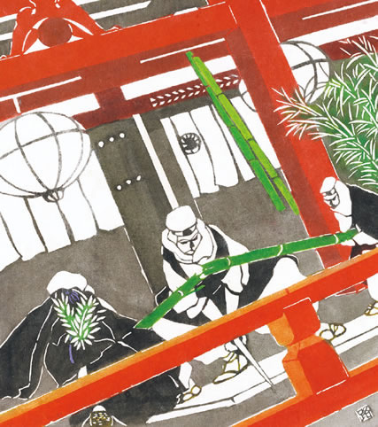
The art work on this page was created for this calendar by Kyoto textile artist Michiko Kasugai. It depicts the exciting Bamboo-cutting Ceremony held at Kurama-dera temple in June. The highway from Kurama-guchi leads through the rugged mountains to this area. The bamboo-cutting ceremony honors the ancient legend that during his religious training at the temple, the priest Buen conquered an evil serpent. Dressed as warrior priests, the performers, divided into the Omi and Tanba camps, compete in chopping huge lengths of green bamboo, representing the serpent.
July - August:Around the Kojin-guchi Portal to Kyoto
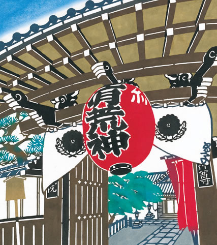
The art work on this page was created for this calendar by Kyoto textile artist Keiko Kanesaki. Depicted is the entrance of Gojoin temple, located in the inner-city section nearby Kojin-guchi, a busy location near downtown Kyoto. This relatively small temple is dedicated to the deity that protects households against fire. Located close to the southeastern corner of the imperial palace grounds, it served the role of protecting the Imperial Palace against fire, and for this, out of the hundreds of smaller temples to be found in Kyoto, it was patronized by the imperial family.
September - October:Around the Awata-guchi Portal to Kyoto
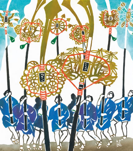
The art work on this page was created for this calendar by Kyoto textile artist Hideharu Naito. It is a scene of the festival of Awata Shrine, by the old Awata-guchi portal which led onto the Tokaido highway. Tokaido travelers would pray at Awata Shrine for a safe journey. The portrayed scene is of the impressive halberd procession held to clear the way for the deity. The halberds, nearly 8 meters tall and weighing 40 to 60 kilograms, are each carried by an individual bearer. The blades have been handed down through the ages and are preserved as historical treasures.
November - December:Around the Toji-guchi Portal to Kyoto
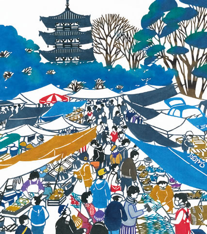
The art work on this page was created for this calendar by Kyoto textile artist Keiko Kanesaki. We see the throng gathered at Toji temple, located around the old Toji-guchi portal at the southwest corner of Kyoto. Toji temple is connected with Kukai, familiarly known as the Great Teacher Kobo, and. every month on the 21st, the memorial day of his death in 835, a memorial is held here. It attracts thousands of visitors, perhaps especially for the various vendor stalls which fill the compound on this day. The last memorial day of the year, the event is held on grand scale.